Connecting Cleveland's Waterfronts
Cleveland is a city defined by water, but many Clevelanders don't experience it that way.
From the very beginning, Lake Erie and the Cuyahoga River shaped this city and propelled its growth — moving goods, supporting industry, and connecting the Cleveland to the rest of the world.
But for more than a century, Clevelanders have been separated from their lake and riverfront by infrastructure built for a bygone era.
As we enter the Cleveland ERA, we have a historic opportunity to reconnect with these precious assets and stitch them back together — making barriers into bridges, reimagining underused land, and transforming disconnected spaces into one unified, accessible, and inspiring two-waterfront city.
Reimagining Burke Lakefront Airport
Cleveland has a once-in-a-generation opportunity to transform nearly 450 acres of prime lakefront land currently inaccessible to the public into a vibrant, accessible, and economically productive destination for all residents.
Located along two miles of Lake Erie shoreline, Burke Lakefront Airport represents one of the most significant redevelopment opportunities in our city’s history.
The North Coast Waterfront Development Corporation, is engaging residents, stakeholders, and partners to identify opportunities to unlock the potential of Burke Lakefront Airport.
Take the survey to help shape the future of Cleveland’s lakefront
A Lakefront Without Limits
Expanding public access strengthens connectivity, enhances quality of life, and creates a vibrant, inclusive waterfront for all Clevelanders.
Responsible Today. Sustainable Tomorrow.
Smart, forward-looking investments can drive economic growth while protecting long-term fiscal health.
Unique Opportunities with Local Impact
Redevelopment can unlock investment, support small businesses, create jobs, and keep capital circulating locally — reinforcing Cleveland’s regional leadership

Our Priorities
Public Access: Create a more connected and inclusive lakefront, expanding opportunities for Clevelanders to live, work, and spend time by the water.
Economic Impact: Opening this land creates opportunities for job growth, small business development, and catalytic investment that increases tax revenue to the City of Cleveland.
Cost: Identifying development strategies that minimize or eliminate reliance on public funding.
Market Reality: Focusing on uses that complement existing development across the city.
Air Show Continuity: Collaborating to ensure the Cleveland Air Show can continue as a signature annual event.
Business Transition: Supporting existing airport users, including medical transport and aviation partners, in transitioning operations.

Fast Facts
- Burke Lakefront Airport is 450 acres of city-owned lakefront land and 2 miles of shoreline along Lake Erie
- FAA anticipates flights from Burke will continue to decline through 2050. Burke operates at a $1.7M annual operating loss (2025). The deficit subsidized by Cleveland Hopkins International Airport
- Burke primarily serves private and business aviation (transferable to Hopkins or other nearby airports)
- Site easily supports low-density development and recreational uses.
Conceptual Fit Study
NCWDC spearheaded a collaborative effort with civic partners to identify an initial, conceptual plan for Burke Lakefront Airport. The draft conceptual plan and economic impact study considers the unique qualities of Burke and combines three key principles:
- Increased economic impact in the form of both increased direct tax revenue and benefits to the local economy. Either concept offers at least five times more direct economic impact to the City of Cleveland than operations of Burke currently provides and likely offers greater indirect economic output as Burke currently provides.
- Increased ability for Clevelanders to access 450 acres of publicly owned waterfront land. The conceptual plans incorporate community facilities that can be used by Clevelanders, park and play space, and nearly 10 miles of walking trails.
- Financial viability that minimizes construction and operational costs borne by the City. The uses proposed can be privately financed and supported by partners.
If the City were to officially move forward with the redevelopment of Burke, NCWDC will engage more formal planning consultation and would conduct more extensive community engagement.
Timing & Path Forward
There are two potential pathways to closing Burke Lakefront Airport:
- FAA Process: A standard, federally regulated closure pathway
- Congressional Authorization: Legislative action enabling closure, followed by a structured transition
The City is committed to pursuing the most responsible and efficient path forward.
Financial Overview
Burke has operated at a deficit for over 20 years, averaging approximately $900,000 annually.
- The 2025 deficit reached a high of $1.7 million
- Costs are expected to rise due to aging infrastructure and deferred maintenance
- Continued operations represent significant opportunity cost
Reports & Resources
Explore the data and analysis informing this work:
Two Waterfronts. One Cleveland.
We're working toward a Cleveland where economic momentum and quality of life go hand in hand, and where every resident can feel connected to our greatest natural assets.
Learn more about the projects making that vision a reality.
The North Coast Connector is a proposed land bridge connecting the grassy lawns of Mall C and City Hall to the lakefront. It will span over the railroad tracks and the Shoreway (State Route 2) to restore access and repair more than a century-old divide, opening up new land for community gatherings and future economic development.
State Route 2 will be reduced from a limited access freeway to a safer lower-speed local boulevard. The North Coast Connector also integrates a new multi-modal transit facility in its design that will connect the existing Amtrak and light rail tracks and other modes.
The City has led substantial public engagement to reimagine the lakefront to balance public green space and economic development opportunities. Working collaboratively with the North Coast Waterfront Development Corporation to see the project through, the development plan includes 16 acres of dedicated green space, a new multi-modal transportation hub, 1,300 new mixed-income residential units, and 3 million square feet of new office, retail, and entertainment uses.
Proposed North Coast Connector
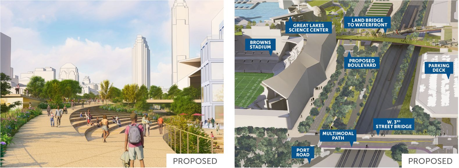
The images above show the proposed North Coast Connector. The land bridge would extend from the grassy area next to Cleveland City Hall to the lakefront, crossing over the railroad tracks and State Route 2 Cleveland Memorial Shoreway.
Converting the Shoreway to a Boulevard
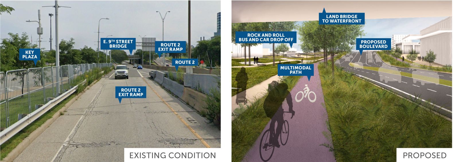
These images show how the Shoreway would be converted from a limited-access highway with a 55-mph speed limit to a 35-mph boulevard with new intersections, sidewalks and a multi-use path. The view shown on the right is under the land bridge, looking east near Great Lakes Science Center.
West 3rd Intersection
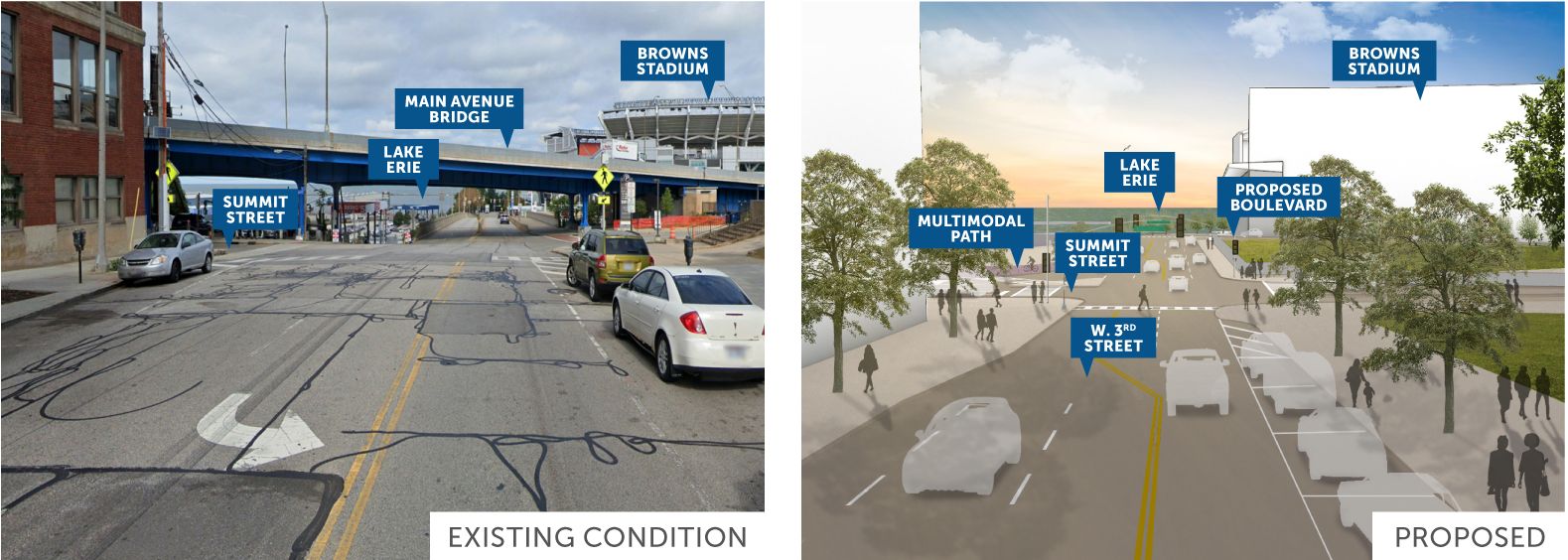
These images show the West 3rd intersection today and what is proposed.
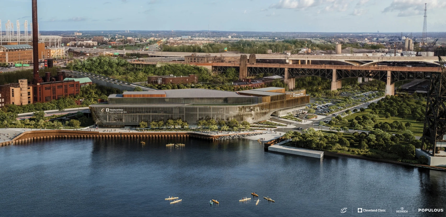
The Cleveland Clinic Global Peak Performance Center is the first vertical development of Bedrock’s 3.5 million-square-foot master plan, which will activate 12 acres of accessible space, including a riverwalk and green space.
The Riverfront project is part of Cleveland’s Vision for the Valley, a multi-year comprehensive plan for the Riverfront adopted and refined by developer Bedrock, who is partnering with the City to implement public improvements in an innovative public-private partnership. The Cuyahoga Riverfront – which backs up to Tower City, a Bedrock property serving as Cleveland’s central light rail and transit hub—is currently inaccessible to pedestrians and cyclists from the city center.
Planned investments in the Cuyahoga Riverfront will create dynamic and accessible access to the Riverfront that will serve as an entertainment and leisure hub to people of all abilities. This catalytic transit-oriented development project will unlock economic development sites along the Cuyahoga River.
The development plan includes 12 acres of dedicated green space, enhanced multi-modal transportation opportunities, 2,000 new residential units, and 1.4 million square feet of new office, retail, and entertainment uses.
Working together, Bedrock and the City of Cleveland have prepared the Cuyahoga Riverfront Master Development Plan to transform 35 acres of inaccessible property along the shores of the Cuyahoga River and provide connectivity to Tower City Center and the downtown core. This once-in-a-lifetime opportunity to develop a unique and dynamic 35-acre transit-oriented neighborhood will weave 3.5 million square feet of new residential and mixed use development together with 12 acres of public parks along 3,000 linear feet of accessible boardwalk on the riverfront.
Cleveland's Shore-to-Core-to-Shore initiative comprises innovative transportation and redevelopment projects focused on three key areas: the Lakefront (Shore), Downtown (Core), and Riverfront (Shore).
These projects aim to enhance safe access and efficient connections to Cleveland's waterfronts while unlocking economic development opportunities by repurposing vacant and underutilized land to stimulate economic growth and enhance the quality of life for residents.
The City has taken an innovative approach to financing by adopting a tax-increment financing (TIF) district over its downtown. Over 42 years, the TIF District is estimated to generate between $3.3B and $7.5B. The primary goal for the TIF District is to fund the Shore-to-Core-to-Shore public improvements.